Christ Redeemer: Rio de Janeiro, Brazil
This statue of Jesus stands some 38 meters tall, atop the Corcovado mountain overlooking Rio de Janeiro. Designed by Brazilian Heitor da Silva Costa and created by French sculptor Paul Landowski, it is one of the world’s best-known monuments. The statue took five years to construct and was inaugurated on October 12, 1931. It has become a symbol of the city and of the warmth of the Brazilian people, who receive visitors with open arms.
In the 1850s the Vincentian priest Pedro Maria Boss suggested placing a Christian monument on Mount Corcovado to honour Isabel, princess regent of Brazil and the daughter of Emperor Pedro II, although the project was never approved. In 1921 the Roman Catholic archdiocese of Rio de Janeiro proposed that a statue of Christ be built on the 2,310-foot (704-metre) summit, which, because of its commanding height, would make it visible from anywhere in Rio. Citizens petitioned Pres. Epitácio Pessoa to allow the construction of the statue on Mount Corcovado.
Permission was granted, and the foundation stone of the base was ceremonially laid on April 4, 1922—to commemorate the centennial on that day of Brazil’s independence from Portugal—although the monument’s final design had not yet been chosen. That same year a competition was held to find a designer, and the Brazilian engineer Heitor da Silva Costa was chosen on the basis of his sketches of a figure of Christ holding a cross in his right hand and the world in his left. In collaboration with Brazilian artist Carlos Oswald, Silva Costa later amended the plan; Oswald has been credited with the idea for the figure’s standing pose with arms spread wide. The French sculptor Paul Landowski, who collaborated with Silva Costa on the final design, has been credited as the primary designer of the figure’s head and hands. Funds were raised privately, principally by the church. Under Silva Costa’s supervision, construction began in 1926 and continued for five years. During that time materials and workers were transported to the summit via railway.

After its completion, the statue was dedicated on October 12, 1931. Over the years it has undergone periodic repairs and renovations, including a thorough cleaning in 1980, in preparation for the visit of Pope John Paul II to Brazil that year, and a major project in 2010, when the surface was repaired and refurbished. Escalators and panoramic elevators were added beginning in 2002; previously, in order to reach the statue itself, tourists climbed more than 200 steps as the last stage of the trip. In 2006, to mark the statue’s 75th anniversary, a chapel at its base was consecrated to Our Lady of Aparecida, the patron saint of Brazil.
GREAT WALL OF CHINA: CHINA
The Great Wall of China was built to link existing fortifications into a united defense system and better keep invading Mongol tribes out of China. It is the largest man-made monument ever to have been built and it is disputed that it is the only one visible from space. Many thousands of people must have given their lives to build this colossal construction.
Perhaps the most recognizable symbol of China and its long and vivid history, the Great Wall of China actually consists of numerous walls and fortifications, many running parallel to each other. Originally conceived by Emperor Qin Shi Huang (c. 259-210 B.C.) in the third century B.C. as a means of preventing incursions from barbarian nomads into the Chinese Empire, the wall is one of the most extensive construction projects ever completed.
The best-known and best-preserved section of the Great Wall was built in the 14th through 17th centuries A.D., during the Ming dynasty (1368-1644). Though the Great Wall never effectively prevented invaders from entering China, it came to function more as a psychological barrier between Chinese civilization and the world, and remains a powerful symbol of the country’s enduring strength.
Machu Picchu: Peru
In the 15th century, the Incan Emperor Pachacútec built a city in the clouds on the mountain known as Machu Picchu (“old mountain”). This extraordinary settlement lies halfway up the Andes Plateau, deep in the Amazon jungle and above the Urubamba River. It was probably abandoned by the Incas because of a smallpox outbreak and, after the Spanish defeated the Incan Empire, the city remained ‘lost’ for over three centuries. It was rediscovered by Hiram Bingham in 1911.
7,000 feet above sea level and nestled on a small hilltop between the Andean Mountain Range, the majestic city soars above the Urabamba Valley below. The Incan built structure has been deemed the “Lost Cities”, unknown until its relatively recent discovery in 1911. Archaeologists estimate that approximately 1200 people could have lived in the area, though many theorize it was most likely a retreat for Incan rulers. Due to it’s isolation from the rest of Peru, living in the area full time would require traveling great distances just to reach the nearest village.
Separated into three areas - agricultural, urban, and religious - the structures are arranged so that the function of the buildings matches the form of their surroundings. The agricultural terracing and aqueducts take advantage of the natural slopes; the lower areas contain buildings occupied by farmers and teachers, and the most important religious areas are located at the crest of the hill, overlooking the lush Urubamba Valley thousands of feet below.
Hikers, tourists, and the early explorers describe similar emotions as they climb their way through the Inca Trail. Many call the experience magical. Glancing out from the Funerary Rock Hut on all the temples, fields, terraces, and baths seems to take you to another time. Blending in with the hillside itself, many say the area creates a seamless and elegant green paradise, making it a must for anyone who travels to Peru.
-
On the edge of the Arabian Desert, Petra was the glittering capital of the Nabataean empire of King Aretas IV (9 B.C. to 40 A.D.). Masters of water technology, the Nabataeans provided their city with great tunnel constructions and water chambers. A theater, modelled on Greek-Roman prototypes, had space for an audience of 4,000. Today, the Palace Tombs of Petra, with the 42-meter-high Hellenistic temple facade on the El-Deir Monastery, are impressive examples of Middle Eastern culture.
The city of Petra, capital of the Nabataean Arabs, is one of the most famous archaeological sites in the world, it is Located 240 km south of the capital Amman and 120 km north of the red sea town of Aqapa Petra the world wonder is undoubtedly Jordan's most valuable treasure and greatest tourist attraction, and it is visited by tourists from all over the world.
It is not known precisely when Petra was built, but the city began to prosper as the capital of the Nabataean Empire from the 1st century BC, which grew rich through trade in frankincense, myrrh, and spices. Petra was later annexed to the Roman Empire and continued to thrive until a large earthquake in 363 AD destroyed much of the city in the 4th century AD.
The earthquake combined with changes in trade routes, eventually led to the downfall of the city which was ultimately abandoned. By the middle of the 7th century Petra appears to have been largely deserted and it was then lost to all except local Bedouin from the area. In 1812 a Swiss explorer named Johannes Burckhardt set out to ‘rediscover’ Petra; he dressed up as an Arab and convinced his Bedouin guide to take him to the lost city, After this, Petra became increasingly known in the West as a fascinating and beautiful ancient city, and it began attracting visitors and continues to do so today.
Petra is also known as the rose-red city, a name it gets from the wonderful colour of the rock from which many of the city’s structures were carved. The Nabataeans buried their dead in intricate tombs that were cut out of the mountain sides and the city also had temples, a theater, and following the Roman annexation and later the Byzantine influence, a colonnaded street and churches. In addition to the magnificent remains of the Nabataean city, human settlement and land use for over 10,000 years can be traced in Petra, where great natural, cultural, archaeological and geological features merge.
Pyramid at Chichén Itzá: Yucatan Peninsula, Mexico
Chichén Itzá, the most famous Mayan temple city, served as the political and economic center of the Mayan civilization. Its various structures – the pyramid of Kukulkan, the Temple of Chac Mool, the Hall of the Thousand Pillars, and the Playing Field of the Prisoners – can still be seen today and are demonstrative of an extraordinary commitment to architectural space and composition. The pyramid itself was the last, and arguably the greatest, of all Mayan temples.
The town of Chichen-Itza was established during the Classic period close to two natural cavities (cenotes or chenes), which gave the town its name "At the edge of the well of the Itzaes". The cenotes facilitated tapping the underground waters of the area. The dates for this settlement vary according to subsequent local accounts: one manuscript gives 415-35 A.D., while others mention 455 A.D. The town that grew up around the sector known as Chichen Viejo already boasted important monuments of great interest: the Nunnery, the Church, Akab Dzib, Chichan Chob, the Temple of the Panels and the Temple of the Deer. They were constructed between the 6th and the 10th centuries in the characteristic Maya style then popular both in the northern and southern areas of the Puuc hills.

The second settlement of Chichen-Itza, and the most important for historians, corresponded to the migration of Toltec warriors from the Mexican plateau towards the south during the 10th century. According to the most common version, the King of Tula, Ce Acatl Topiltzin Quetzalcoatl, or Kukulkan as the Maya translated the name, reportedly took the city between 967 A.D. and 987 A.D. Following the conquest of Yucatán a new style blending the Maya and Toltec traditions developed, symbolizing the phenomenon of acculturation. Chichen-Itza is a clear illustration of this fusion. Specific examples are, in the group of buildings to the south, the Caracol, a circular stellar observatory whose spiral staircase accounts for its name, and, to the north, El Castillo (also known as the Temple of Kukulkan). Surrounding El Castillo are terraces where the major monumental complexes were built: on the north-west are the Great Ball Court, Tzompantli or the Skull Wall, the temple known as the Jaguar Temple, and the House of Eagles; on the north-east are the Temple of the Warriors, the Group of the Thousand Columns, the Market and the Great Ball Court; on the south-west is the Tomb of the High Priest. After the 13th century no major monuments seem to have been constructed at Chichen-Itza and the city rapidly declined after around 1440 A.D. The ruins were not excavated until 1841 A.D.
Roman Colosseum: Rome, Italy

This great amphitheater in the centre of Rome was built to give favors to successful legionnaires and to celebrate the glory of the Roman Empire. Its design concept still stands to this very day, and virtually every modern sports stadium some 2,000 years later still bears the irresistible imprint of the Colosseum’s original design. Today, through films and history books, we are even more aware of the cruel fights and games that took place in this arena, all for the joy of the spectators.
The Roman Colosseum or Coliseum, originally known as the Flavian Amphitheatre, was commisioned in AD 72 by Emperor Vespasian. It was completed by his son, Titus, in 80, with later improvements by Domitian.
The Colosseum is located just east of the Roman Forum and was built to a practical design, with its 80 arched entrances allowing easy access to 55,000 spectators, who were seated according to rank. The Coliseum is huge, an ellipse 188m long and 156 wide. Originally 240 masts were attached to stone corbels on the 4th level.
Just outside the Coliseum is theArch of Constantine (Arco di Costantino), a 25m high monument built in AD315 to mark the victory of Constantine over Maxentius at Pons Milvius.
Vespesian ordered the Colosseum to be build on the site of Nero's palace, the Domus Aurea, to dissociate himself from the hated tyrant.
His aim was to gain popularity by staging deadly combats of gladiators and wild animal fights for public viewing. Massacre was on a huge scale: at inaugural games in AD 80, over 9,000 wild animals were killed.
Taj Mahal: Agra, India
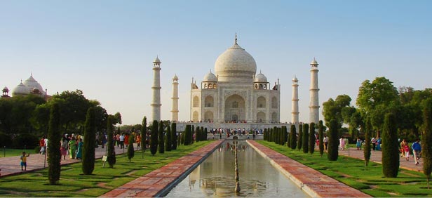
This immense mausoleum was built on the orders of Shah Jahan, the fifth Muslim Mogul emperor, to honor the memory of his beloved late wife. Built out of white marble and standing in formally laid-out walled gardens, the Taj Mahal is regarded as the most perfect jewel of Muslim art in India. The emperor was consequently jailed and, it is said, could then only see the Taj Mahal out of his small cell window.
Agra is the city of Taj Mahal, which makes it the most popular city of India. It is located near the River Yamuna on the northern state Uttah Pradesh of India, and is the most populated city of Uttah Pradesh with more than 1.5 million people. In the famous epic Mahabharat, Agra was referred as the forest of Agraban, and the epic dates the foundation of the city to 1475 during the reign of Rājā Badal Singh. However a Persian poet named Mas'ūd Sa'd Salmān mentions about Agra in the 11th century. The ancient fort of Agra, Badalgarh, from the reign of Rājā Badal Singh should be somewhere near or on the present fort.

In 1506, Sultan Sikandar Lodī moved the capital from Delhi to Agra. His son Ibrahim Lodī also used Agra as the capital until he was defeated by the Persian King Babur. Babur was the founder of the Mughal Empire and he sent his son Humayun to capture the city. Mughal empire not only captured Agra, but also the largest diamond of that time, Koh-i-Noor. Under the dominion of Mughals, Agra lived its heydays between 1526 and 1658 and it was called Akbarabād.
Muhgals were famous with their love of architecture, and the most of the fascinating buildings that one can see today belong to the Mughal period between 15th and 16th centuries including the three UNESCO World Heritages: Taj Mahal, Agra Fort and Fatehpūr Sikrī. |
|
Baburs’ grandson Akbar made Akbarabād the center of arts, culture and commerce and religion. He constructed many beautiful buildings including the city Fatehpūr Sikrī which was inspired by a Mughal military camp.
In the 17th century, Cihangir ( Jahangiri) made Akbarabād the hotspot of Muslim world. His son Sah Cihan (Shahjahan) ordered the Taj Mahal to be constructed in memory of his beloved wife Mumtaz Mahal. The mausoleum was completed in 1653. After that, Shah Jahan moved the capital back to Delhi and this made Agra lose its importance.
After the decline of the Mughal Empire, the city went under the influence of Marathats and Jads, and started to be called as Agra. In 1803, the city went under the British domination which continued until the independence of India in 1947. |


